There are 8 high school codes in Guyana today, according to the ACT. The full list is shown below by city, with name of each high school and the city where the school is located (based on the ACT official site). You can search a school code by pressing “Ctrl” + “F” and then type school name or 6-digit school code.
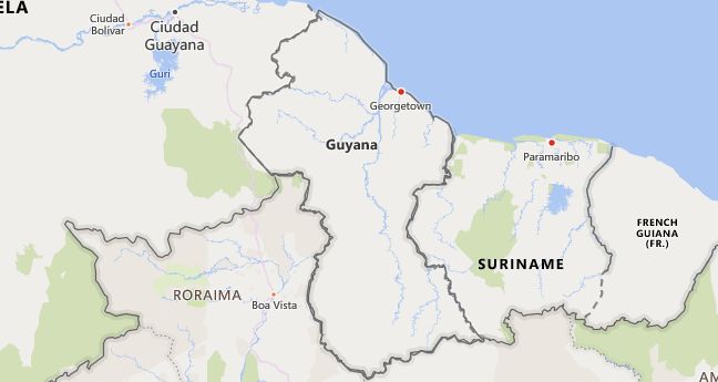
Map of Guyana
High School Codes by City
- High School Code
- 915303
- High School Code
- 915301
- High School Code
- 915050
- High School Code
- 915121
- High School Code
- 915241
- High School Code
- 915150
- High School Code
- 915255
- High School Code
- 915242
The above lists CEEB codes (College Entrance Examination Board) for all accredited Guyana high schools. Please be informed that the list of high school codes in Guyana may change throughout the year. If you can’t find codes for the high schools of your interest, please write to us or come back at a later time. We will update our database soon after a new high school code is added to the country of Guyana.
Country Abbreviations
GUY is the three-letter country code of Guyana, and GY is the two-letter country code of Guyana. The two-letter suffix is used in top-level domains on the Internet as .gy.
Country Overview
Guayna is a presidential republic on the northeast coast of South America with the capital Georgetown. It is about two thirds the size of Germany and the westernmost of the Guiana countries, which also include Suriname and French Guiana. The mountainous landscapes in the interior of Guyana are part of the Guiana Mountains. The 20–70 km wide coastal plain is partly 1–5 m below sea level and has to be protected by dikes. Around 70% of the country is covered by species-rich tropical rainforest. The population is concentrated in the coastal plain and around Georgetown. The largest ethnic group with around 40% are the descendants of Indian contract workers who came to Guyana after the abolition of slavery (1833). Around 29% of the population are black, whose ancestors were abducted from Africa by European colonial powers. 20% are of mixed origin, 10% mostly indigenous people living in inaccessible inland areas. The area of today’s Guyana was founded in 1499 by the Spaniard A. de Hojeda discovered. At the end of the 16th and beginning of the 17th centuries, Dutch, English and French settlements emerged, which subsequently changed hands frequently. Ultimately in British possession since 1816, under the name British Guiana since 1831, Guyana became a crown colony in 1928. In 1966 it gained independence under the Commonwealth of Nations. In 1979 the country became a republic. As a former British colony, Guyana is now the only English-speaking nation on the Latin American continent. Due to its colonial history, it is culturally closely linked to the Caribbean islands. Colonial architecture in the Gothic style has been preserved in the old town of Georgetown. The canals that characterize the cityscape were created by Dutch settlers. A contemporary writer who is well-known beyond national borders is J. Carew . His most important novel is »Black Midas« (1958; German »Schwarzer Midas«), which addresses the search for identity of the black population (Caribbean literature). Despite its mineral wealth, Guyana is one of the poorer nations in South America. The main pillars of the economy are the agricultural sector and gold and bauxite mining. The country could become a major global oil producer after huge oil deposits were discovered off the coast in 2015.
Country facts
- Official name: The Cooperative Republic of Guyana
- License plate: GUY
- ISO-3166: GY, GUY (328)
- Internet domain:.gy
- Currency: 1 Guyana dollar (G $) = 100 cents
- Area: 214,970 km²
- Population (2018): 779,000
- Capital: Georgetown
- Official language (s): English
- Form of government: Presidential Republic
- Administrative division: 10 regions
- Head of State: President Mohamed Irfaan Ali (since 2.8.2020)
- Religion (s): Christians, Hindus, Muslims
- Time zone: Central European Time -5 hours
- National Day: February 23
Location and infrastructure
- Location (geographical): South America
- Position (coordinates): between 1 ° and 8 ° 30 ‘north latitude and 56 ° 27’ and 61 ° 28 ‘west longitude
- Climate: Tropical rainforest climate
- Highest mountain: Roraima (2,810 m)
- Road network (2019): 799 km (paved), 3 196 km (unpaved)
Population
- Annual population growth (2020): 0.7%
- Birth rate (2020): 15.5 per 1,000 residents.
- Death rate (2020): 7.5 per 1,000 residents.
- Average age (2020): 27.5 years
- Average life expectancy (2020): 69.5 years (men 66.5; women 72.6)
- Age structure (2020): 23.9% younger than 15 years, 7.0% older than 65 years
- Literacy rate (15-year-olds and older) (2015): 88.5%
- Mobile phone contracts (pre-paid and post-paid) (2017): 83 per 100 residents
- Internet users (2017): 37 per 100 residents
Economy
- GDP per capita (2018): US $ 4,649
- Total GDP (2018): $ 3,636 billion
- GNI per capita (2018): US $ 4,770
- Education expenditure (2017): 6.3% of GDP
- Military expenditure (2018): 1.7% of GDP
- Unemployment rate (15 years and older) (2017): 11.8%
Climate and vegetation
The climate is tropical with mean annual temperatures between 24 ° C and 28 ° C and annual rainfall of 2,000 mm to 3,000 mm in the north and up to 1,500 mm in the south (two rainy seasons). Over three quarters of the interior is covered by tropical rainforest, which turns into wet savannah in the southwest; A wide belt of mangroves and swamp forests runs parallel to the coast.
Environmental problems arise because of the uncontrolled deforestation of the rainforest and the pollution of the waters by the bauxite mining.

