There are 10 high school codes in North Korea today, according to the ACT. The full list is shown below by city, with name of each high school and the city where the school is located (based on the ACT official site). You can search a school code by pressing “Ctrl” + “F” and then type school name or 6-digit school code.
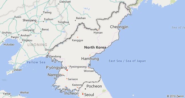
Map of North Korea
High School Codes by City
- High School Code
- 682420
- High School Code
- 682387
- High School Code
- 682041
- High School Code
- 682011
- High School Code
- 682182
- High School Code
- 682222
- High School Code
- 682350
- High School Code
- 682008
- High School Code
- 682380
- High School Code
- 682386
The above lists CEEB codes (College Entrance Examination Board) for all accredited North Korean high schools. Please be informed that the list of high school codes in North Korea may change throughout the year. If you can’t find codes for the high schools of your interest, please write to us or come back at a later time. We will update our database soon after a new high school code is added to the country of North Korea.
Country Abbreviations
PRK is the three-letter country code of North Korea, and KP is the two-letter country code of North Korea. The two-letter suffix is used in top-level domains on the Internet as .kp.
Country Overview
North Korea is a republic in the northern part of Korea, which has been divided since 1948, with Pyongyang as its capital. Since the end of the Korean War (1950–53), the border with South Korea has been a heavily fortified and impermeable armistice line that runs near the 38th parallel.
Four fifths of North Korean territory is mountainous. To the east the mountains drop steeply to the Sea of Japan, to the southwest they merge to the Yellow Sea in coastal plains and valleys. The climate is cool-temperate. The long winters are severe and dry, the short summers hot and humid.
The country has only half the population of South Korea, although it is a quarter larger. The population consists almost entirely of Koreans. The southwest is the most densely populated. People are closely monitored. Freedom of expression and freedom of the press do not exist. North Korea is sealed off from the outside. Nobody is allowed to travel or leave the country without permission.
The economy is largely planned and managed centrally. Agriculture generates a fifth of the national economic output. Nevertheless, it cannot supply the population with sufficient food. As a result, farmers have been able to sell some of their products on open markets since 2012. North Korea has large reserves of raw materials, especially coal and metal ores. The industrial plants are outdated and the infrastructure is poor. New hydropower plants are supposed to remedy the energy shortage.
North Korea is a dictatorship with the Communist Party of Work Korea as a state party (communism). Since the partition of Korea, the father, son and grandson of the Kim family have been at the forefront of state and society, and since 2011 Kim Jong Un (* 1984 ). His power rests primarily on the army, one of the largest in the world.
North Korea has been developing and testing long-range missiles and nuclear weapons since the 1990s. Penalties have therefore been imposed internationally. In the meantime and from 2019 there were also negotiations to dissuade North Korea from its nuclear program. The People’s Republic of China is North Korea’s most important alliance and trading partner.
Country facts
- Official name: Democratic People’s Republic of Korea
- License plate: KP
- ISO-3166: KP, PRK (408)
- Internet domain:.kp
- Currency: 1 won = 100 chon
- Area: 120 540 km²
- Population (2018): 25.5 million
- Capital: Pyongyang
- Official language (s): Korean
- Form of government: People’s Republic
- Administrative division: 9 provinces, 3 special regions, capital
- Head of State: Choe Ryong Hae (protocol)
- Religion (s): Confucians, followers of shamanism
- Time zone: Central European Time +7 hours
- National holiday: September 9th
Location and infrastructure
- Location (geographical): East Asia
- Position (coordinates): between 38 ° and 43 ° north latitude and 124 ° and 131 ° east longitude
- Climate: Cool, moderate, dry winter climate
- Highest mountain: Paektusan (2744 m)
- Road network (2006): 724 km (paved), 24 830 km (unpaved)
- Railway network (2014): 7,435 km
Population
- Annual population growth (2018): 0.5%
- Birth rate (2018): 14.6 per 1000 residents.
- Death rate (2018): 9.3 per 1000 residents.
- Average age (2018): 34.2 years
- Average life expectancy (2018): 71 years (men 67.2; women 75)
- Age structure (2018): 20.6% younger than 15 years, 9.5% older than 65 years
- Literacy rate (15 year olds and older) (2015): 100%
- Mobile phone contracts (pre-paid and post-paid) (2017): 15 per 100 residents
- Internet user: n / a
Economy
- GDP per capita: n / a
- Total GDP: n / a
- GNI per capita: n / a
- Education expenditure: n / a
- Military expenditure: n / a
- Unemployment rate (15 years and older) (2017): 4.8%

