South Dakota is a state located in the Midwestern United States. Named after the Lakota and Dakota (Sioux) Indian tribes. South Dakota became a state on November 2, 1889 (at the same time as North Dakota). The state capital is Pierre and the largest city is Sioux Falls.
STATE NAME
The name of the state of South Dakota comes from the name of the US territory Dakota, which in 1889 was divided into two states: North Dakota and South Dakota. The Dakota Territory was named after the Dakota Indians (one of the Sioux peoples) who lived on these lands.
GEOGRAPHY
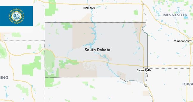
The state of South Dakota is located in the Midwest of the United States and belongs to the northwestern central states of the United States. The area of South Dakota is 199,905 km2 (seventeenth among US states). South Dakota borders the states of Minnesota in the east, Iowa in the southeast, Nebraska in the south, Wyoming in the southwest, Montana in the northwest and North Dakota in the north. Eastern South Dakota is part of the US Central Time Zone, while the western counties are part of the Mountain Time Zone. On the territory of South Dakota, three main physical and geographical regions are distinguished – the lowlands in the east, the Great Plains in the west and the Black Hills mountain range. The natural boundary between the two is the Missouri River, so the eastern counties are often referred to as the East River (“east of the river”), and the western counties as the West River (respectively, “west of the river”). All of eastern South Dakota is part of the US Central Plains. Northeast South Dakota is the Minnesota River Valley, a slightly rolling lowland with very fertile soils. To the south, the low plateau of Cote de Prairie rises above the surrounding area, over which many small lakes are scattered. Several national reserves have been created here, protecting vast wetlands. In the southeast of the state (as well as in neighboring Nebraska and Iowa) there is a region of the so-called “dissected plains”, smoothed by a glacier of gentle hills. Missouri Plateau (or Coteau du Missouri).
CLIMATE
South Dakota has a continental climate with long, cold winters, hot summers, and short but pronounced springs and autumns. The western regions of the state are arid, with much more rainfall in the east, mostly in summer. In the southeast of South Dakota’s largest city, Sioux Falls, the average January temperature ranges from -16°C to -4°C, and July – from 16°C to 30°C. In the central districts of the state, in particular in its capital, Pyrrhus, in the coldest month, temperatures usually range from -14°C to -2°C, and in the hottest – from 17°C to 32°C. In the west, in the city of Rapid City, in winter from -12 ° C to 1 ° C, and in summer – from 14 ° C to 30 ° C. The eastern part of South Dakota is located on “tornado alley”, here often, up to thirty times a year, destructive whirlwinds sweep.
ECONOMY
South Dakota’s economy is based on agriculture, tourism, and US federal government spending. In 2012, South Dakota’s largest city, Sioux Falls, ranked #1 on Forbes magazine’s “best small towns for business and career” list. Due to the “soft” tax legislation in relation to corporations, divisions of several large financial companies operate in the state, Sioux Falls and Rapid City are also regional centers of health and trade. Traditionally, agriculture remains the most important sector of the economy of South Dakota. Although now South Dakota cannot boast of large mineral reserves, coal, limestone, sand and gravel are mined in the state. The main industrial sector of South Dakota is the processing of agricultural products, including the production of ethyl alcohol. In addition, the state produces electronics, various metal structures, plastic products, cartridges, cement, precast concrete, fire extinguishing equipment, and jewelry. One of the largest employers in the state is the government of the United States of America. Several military installations are located in South Dakota, including the large Ellsworth Air Force Base located near Rapid City.
TOURISM
The most famous and extremely popular tourist attraction in South Dakota is, of course, Mount Rushmore National Memorial. Carved out of the rock in the 1930s, images of four US Presidents (George Washington, Thomas Jefferson, Theodore Roosevelt and Abraham Lincoln) attract about three million visitors annually.
Other “tourist” sites in the state include the Badlands National Parks (with very beautiful and unusual landscapes) and Wind Cave (the fifth longest cave in the world, more than 220 km), as well as the state-managed Custer Park, famous for its large herd of bison. In South Dakota, construction continues on a memorial dedicated to the Lakota hero Crazy Horse, which is planned to be the largest sculpture in the world.
The city of Sturgis has been hosting a bikers’ rally (known as the Sturgis Rally) for more than seventy years and is attended by several hundred thousand motorcycle enthusiasts every year.
Largest Counties in South Dakota
South Dakota became a state in 1889 and is known for Mount Rushmore and its role in Native American history. It has 66 counties. 10 Largest Counties in South Dakota 1. Minnehaha County County Facts Population: Approximately 200,000 Area Codes:…
Read more


